

Satellites in space can spot changes to Earth’s climate, and they are providing frightening bird’s-eye views of the wildfires in Australia.
The wildfires burning in the Australian states of New South Wales and Victoria began in November 2019, and they continue to pose severe safety and environmental problems. NBC News reported that thousands of Australians fled their homes on New Year’s Eve, seeking refuge near the ocean. On January 2, NBC News also reported that New South Wales declared a week-long state of emergency, making this the third time an emergency period has been announced since the fires began.
“My last day of the decade felt like the apocalypse,” Sydney-based photojournalist Matt Abbott tweeted on Dec. 31. Abbott, who is covering the wildfires for The New York Times, added: “Been covering the Australian bushfires for the last 6 weeks, but haven’t seen anything like yesterday’s fire that decimated the town of Conjola, NSW.”
My last day of the decade felt like the apocalypse. Been covering the Australian bushfires for the last 6 weeks, but haven’t seen anything like yesterdays fire that decimated the town of Conjola, NSW. #bushfirecrisis #AustralianBushfires #NSWisburning work for @nytimes pic.twitter.com/KmVKqDMKsf
— matthew abbott (@mattabbottphoto) January 1, 2020
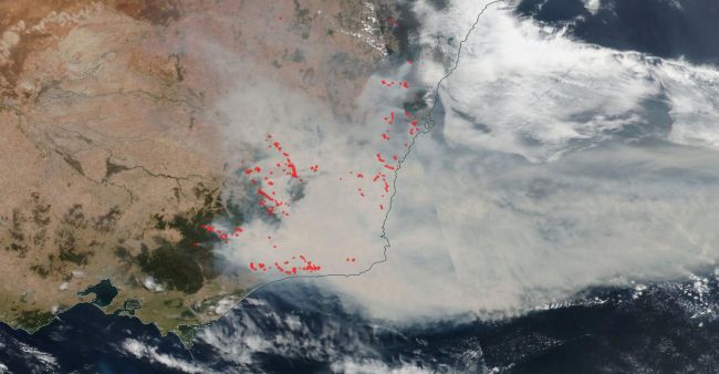
A severe drought in October 2019 primed the country for the ongoing destrution. More than 100 fires raged over the next few months. By Dec. 12, 2019, the wildfires in Australia’s New South Wales scorched an area of about 10,000 square miles (27,000 square kilometers), according to NASA representatives in a description of satellite imagery.
